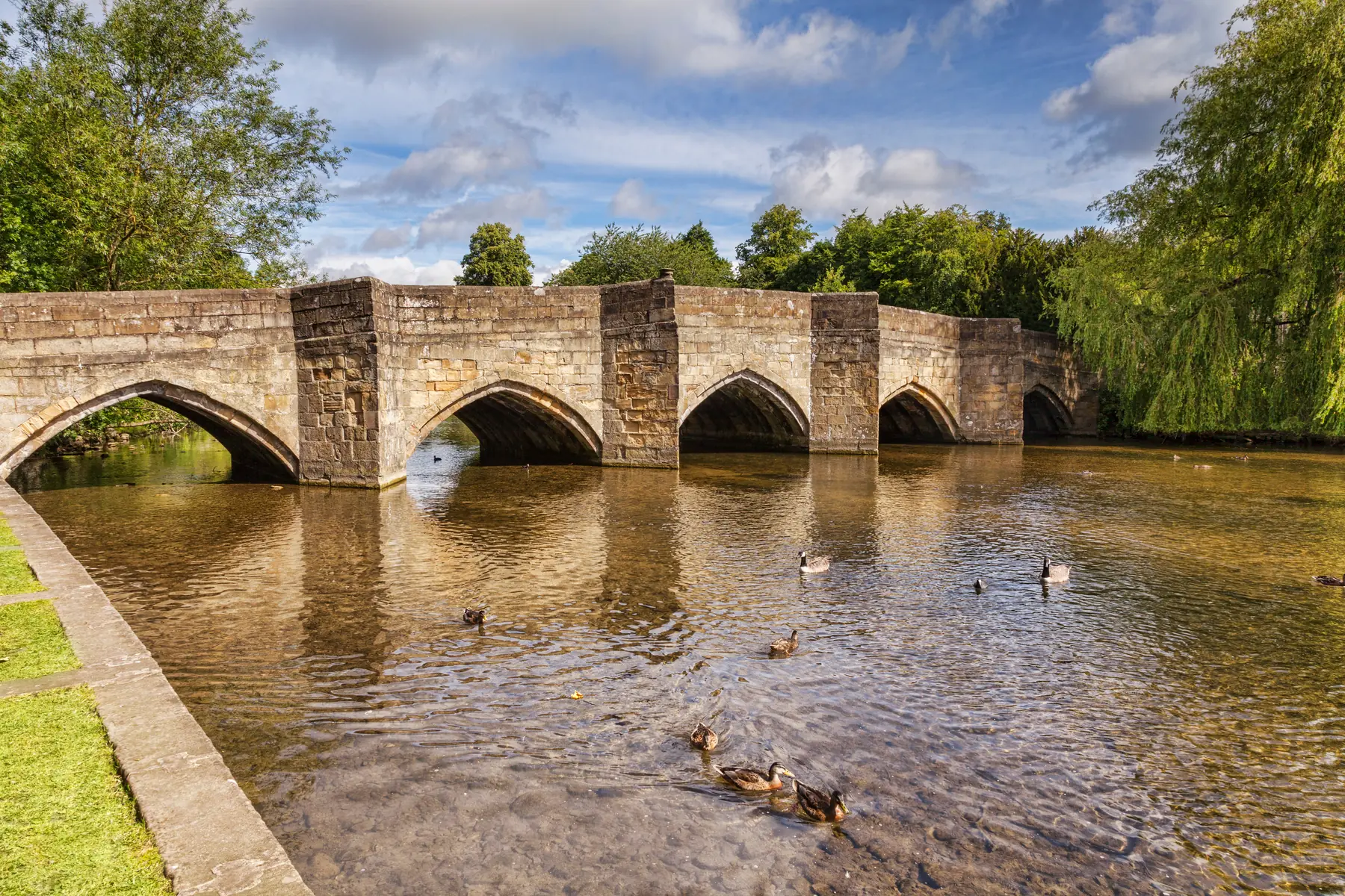
Bakewell is a river town. That is easy to miss if you arrive by car, park at the Agricultural Business Centre and walk into the shops with your back to the water. The Wye is why the settlement is here: a ford, then a bridge, then a market on the west bank. Everything that followed — the church on its hill, the pudding shops, the livestock market, the old railway — hangs off that crossing.
This is the Derbyshire Wye, not the one that runs to Chepstow. Visitors mix them up. Locals do not.
The river that comes through Bakewell rises on the gritstone of Axe Edge, west of Buxton, and runs east through a limestone gorge before it ever reaches the town. It is a tributary of the Derwent. It joins that river at Rowsley, a few kilometres downstream of Haddon Hall. From there the Derwent runs to the Trent. None of this is the Wye of Tintern and Symonds Yat.
It is a smaller river, and a famous one in its own right: a limestone trout stream, and the spine of the White Peak. Dippers and grey wagtails work the riffles. In a dry summer stretches of the wider Wye system disappear into the limestone — a normal feature of this geology. In Bakewell itself the river is held, and it keeps running.
The Peak District National Park is drawn around this valley as much as around the moors. Bakewell is the only town inside the park, on the seam between White Peak limestone and the gritstone edges. The river is the line.
The bridge is the town’s oldest working structure, and it is still doing the original job.
Bakewell Bridge carries the A619 — Bridge Street — over the Wye at the foot of the town. Five pointed arches in ashlar gritstone, ribbed soffits, triangular cutwaters that rise as pedestrian refuges. Grade I listed, a scheduled monument, and generally dated to around 1300, with a widening in the nineteenth century on the upstream side. There is the base of a cross on the downstream cutwater west of the central arch. Historic England’s list entry is 1148112 if you like a primary source.
A stone bridge at Bakewell is mentioned in the reign of Edward I. What you walk across is a medieval crossing asked to carry modern traffic. It does. There is no bypass. Coaches, cattle wagons and the Sheffield bus still go over five gothic arches.
Stand in one of the refuges and look downstream. The Recreation Ground opens on the east bank. The church sits up on the west. The weir is a short walk south. This is the view that explains the town, and it costs nothing. Do not loiter in the carriageway.
South of the bridge the Wye is held by a weir, with a footbridge across to the east bank. Ducks in industrial quantities. People eating fish and chips. Children feeding the water. It is the picture everyone takes, and it is not a fraud: this is how Bakewell uses its river.
The Recreation Ground occupies the east bank immediately below the centre. Municipal grass, a substantial playground, toilets, picnic space, cricket in season, and the town’s main long-stay car park — the Agricultural Business Centre — immediately behind it. For most of the year it is a park. In show weeks it is not; the agricultural show has used this ground since the nineteenth century. Dates move; the when to visit page is the calendar.
The riverside path along the ground is the walk everyone does without planning to. Twenty minutes, entirely flat, from the medieval bridge past the weir and on toward Haddon. It is the introduction to the town rather than a walk in its own right, but it is a good one. Our walks guide picks it up from here.
This stretch is the accessible Bakewell. The climb to the church and the Old House Museum is the other Bakewell, and it is steep.
North of the five-arch bridge the Wye is quieter.
Holme Bridge, a few minutes up the west bank, is a packhorse bridge of 1664: five unequal segmental arches, cutwaters rising to refuges, a low parapet. A different animal from the main crossing — built for animals and people, not for the Worksop road. It is the better place to stand if you want the river without the A619.
Bakewell’s corn mills sat on this water. Arkwright opened a cotton mill in the 1770s; the weirs and mill leats are why the Wye through Bakewell does not look like a wild dale. It is a managed stream in a market town.
The old railway is the other upstream fact. The Midland line of the 1860s ran above the valley, closed in 1968, and is now the Monsal Trail. From the town you climb to the old station and then the Wye appears below you as the valley narrows toward Monsal Head. The Headstone Viaduct, five arches of its own, is the railway’s answer to Bakewell Bridge, seventy feet above the same water.
South from the Recreation Ground the path follows the Wye toward Haddon. About three kilometres, around forty minutes, across meadows, with the house appearing on its wooded rise. It is the nicest approach to a house that most people otherwise reach from a car park on the A6. The Haddon article is the visit; this page is only saying the river takes you there.
Beyond Haddon the Wye swings through Rowsley and takes the Derwent. The dramatic water is the other way: west, through Ashford in the Water, Monsal Dale, Cressbrook and Chee Dale, where the path in places has nowhere to go but into the river on stepping stones. That section is impassable when the Wye is high. It is not a Sunday stroll from the Recreation Ground. It is the same river in a different mood.
Ashford’s Sheepwash Bridge — a packhorse crossing with a walled pen where sheep were washed before shearing — is four kilometres north-west, a different bridge on the same water, and free.
The Bakewell river day is shorter than people expect.
The town loop. Bridge, weir, Recreation Ground, back across the footbridge, up to All Saints if you want the hill. An hour with pauses. Flat until the church.
Bakewell to Haddon and back. The classic. Leave by the Recreation Ground, follow the Wye, look at the house from the meadows even if you are not going in, return the same way. Ninety minutes of walking, more if you sit.
Bakewell to Monsal Head. Not along the bank the whole way. Climb to the old station, take the trail west through the tunnels, drop to the viaduct. The river is below you for miles. Our Monsal Trail guide is the operational document.
A linear day. Walk west on the trail, come back on a Buxton–Bakewell bus along the A6, which shadows the valley. Check the timetable before you set out rather than after. Sundays thin out.
None of this needs a car once you are in town. The car-free guide is that argument. The parking guide is where to leave one if you brought it — the ABC, next to the Recreation Ground, not on the bridge itself.
The Wye through Bakewell is a held river, and it still rises.
After sustained rain the weir is louder, the bank paths are muddy, and the Recreation Ground can be wet underfoot. That is inconvenience. Upstream in Chee Dale it is something else: the stepping stones go under, the path along the cliff base disappears, and people do get caught out. If it has been raining for a day, assume the gorge walks are off. The trail stays usable; that is what the old railway is for.
In high summer the opposite happens in the dales. The Lathkill, a few kilometres west, can vanish into its bed. The Wye at Bakewell, held by weirs, usually does not. A low, clear river under the five arches in August is a normal Bakewell picture. Do not swim under the bridge. The traffic, the weir and the current are not a bathing station.
Bakewell is not a heritage waterfront with the industry removed. The livestock market still operates at the Agricultural Business Centre, a hundred metres from the east bank. On Monday the sound of it carries across the Recreation Ground. Cattle wagons cross the medieval bridge. The A619 is the Sheffield road, not a pedestrian precinct.
That combination is the point. A thirteenth-century crossing, a playground, a working agricultural market and a national park town of four thousand people, all using the same two hundred metres of river. The free things list starts here: the bridge, the weir and the ground cost nothing.
Stand on the downstream refuge at dusk. The church lights up the hill. The Wye runs under five arches toward Haddon. The Welsh river of the same name is a hundred miles west, and it has nothing to do with this. The river is the thing that does not need a ticket, a season or a car park — only a dry stone to stand on, and a look downstream.