Cromford is a village and civil parish of 1,433 people at the 2011 census, in the valley of the River Derwent between Wirksworth and Matlock. It is a factory village in the most literal sense. Richard Arkwright built the world’s first water-powered cotton mill just outside it in 1771, and then built most of the rest: workers’ housing, shops, pubs, chapels, a school, a church, a canal to carry goods out and a castle for himself on the hill opposite. Almost everything a visitor walks to here was put there to serve that mill.
That is the reason to come from Bakewell. Cromford’s mill complex is the centrepiece of the Derwent Valley Mills UNESCO World Heritage Site, and Historic England has called it “one of the country’s 100 irreplaceable sites”. Around it a disused canal towpath and two former railway trackbeds converge, so the industry and the walking here are the same thing.
The straight-line distance from Bakewell is 13.8 km. the village 17 miles (27 km) north of Derby, 2 miles (3.2 km) south of Matlock and 1 mile (1.6 km) south of Matlock Bath. This stretch of the Derbyshire Dales is limestone, and the fast Derwent has cut a deep valley: the A6, the canal and the Derwent Valley Line were all squeezed onto its floor.
Cromford Mill dates from 1771, built to use Arkwright’s water frame. The complex is owned and being restored by the Arkwright Society and works as a visitor centre, Cromford Mills, at 4.5 from 1,671 Google reviews. Restoration is ongoing rather than finished: the Cromford Mills Creative Cluster and World Heritage Site Gateway Project was a 2018 Historic England Angel Awards finalist for major regeneration of a historic place.
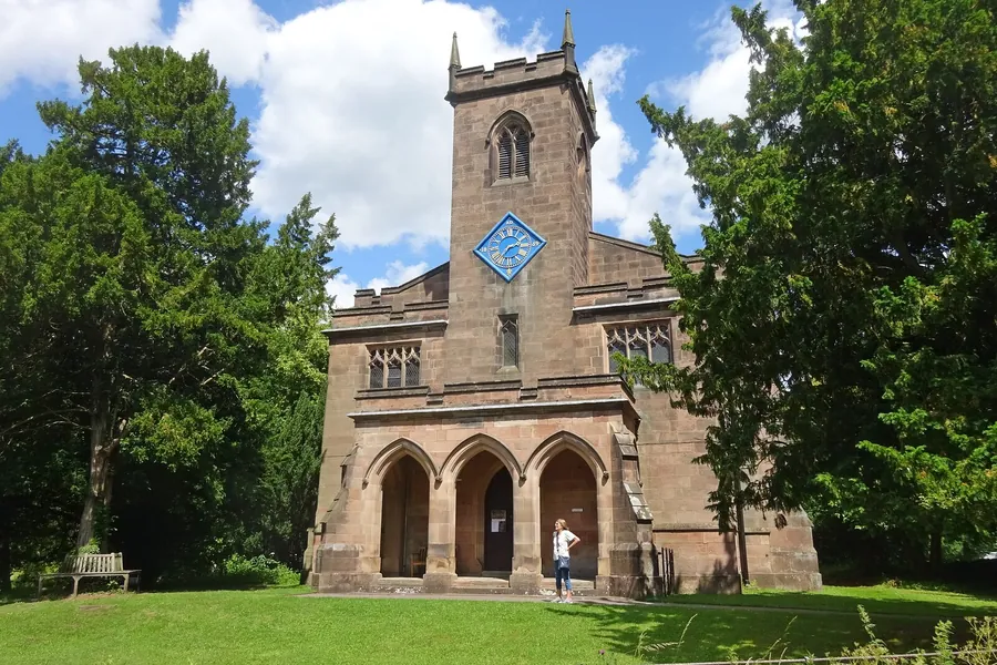
Some cottages and farm buildings pre-date Arkwright, but much of the village was built to house mill workers, and one source cited by these “the first factory housing development in the world”. North Street is the piece to walk: purpose-built workers’ housing rescued from dereliction in the 1970s by the Ancient Monument Society, which sold the houses off; one is now a Landmark Trust holiday cottage. St Mary’s Church was built between 1792 and 1797 by Arkwright, and Masson Mill of 1783 stands on the northern fringe of the village.
Willersley Castle, Grade II* listed, dominates the hill east of the river, above Masson Mill and the village. Arkwright commissioned it, work began in 1790, a fire in 1791 delayed it, he died in 1792 and his son moved in during 1796. The Arkwrights left in 1922, Methodist businessmen opened it as a hotel in 1928, and in the Second World War the Salvation Army ran it as a maternity hospital, evacuated from the East End of London.
The Cromford Canal was built to service the mills. It is disused now and designated a Site of Special Scientific Interest — a working waterway turned wildlife corridor. The towpath runs from Cromford Wharf to High Peak Junction and on to Whatstandwell and Ambergate, and it is level walking in a valley where little else is. Birdswood, a boat tour operator at the Gothic Warehouse by the wharf, has 4.8 from 94 Google reviews; the canal itself shows 4.8 from 58, too small a sample to weigh heavily.
High Peak Junction, 4.6 from 1,627 Google reviews, is where the Cromford and High Peak Railway met the canal. That line was completed in 1831 and ran from the junction to the Peak Forest Canal at Whaley Bridge; its trackbed is now the High Peak Trail, a walking and cycling route joined by the Tissington Trail at Parsley Hay. Leawood Pump House, further along the towpath, carries 4.7 from 167 Google reviews. Black Rocks, at a Cromford address towards Wirksworth, is the highest-rated item on the local list at 4.7 from 1,839, though neither source describes it beyond that.
The shape of Cromford is the result of one piece of engineering. In the early 1800s Scarthin Nick was blasted through with dynamite to carry what later became the A6, separating the Arkwright mill complex on the east side of the main Derby road from the market place and the village at the bottom of the hill that climbs steeply west towards Wirksworth. The village is not flat, and its two halves sit either side of a trunk road.
The Via Gellia valley joins the Derwent here, and the name misleads: the stream is the Ivonbrook and Via Gellia is only the road, built in the late 18th century to connect Cromford and Grangemill by the Gell family, landowners in the Wirksworth lead mining district. This is a working village rather than a preserved one — the 20th century added council and private housing, and Dene Quarry to the south west has been excavated since 1942, operated by Tarmac for aggregates and roadstone.
On scale, be clear: several attractions listed as near Cromford are in fact at Matlock Bath, a mile (1.6 km) north: The Great Masson Cavern at 4.7 from 1,966 Google reviews, Gulliver’s Kingdom at 4.3 from 4,362 and the Peak District Mining Museum at 4.7 from 519. Cromford’s own draw is the mill, the wharf, the housing and the walking, plus the Greyhound Hotel, whose bar is the setting of John Hampson’s 1931 novel Saturday Night at the Greyhound.
By road, the A6 passes just north of the village. it as linking Carlisle with Luton and giving easy access to Manchester, Stockport, Bakewell, Matlock and Derby: it is the connection between the two places.
There is a station, but it is not a route from Bakewell. Cromford railway station sits on the Derwent Valley Line, served by East Midlands Railway with trains generally hourly in each direction between Derby and Matlock — neither of which is Bakewell. It is listed 14.1 km straight-line from Bakewell, carries 4.6 from 40 Google reviews, and appears on the cover of the 1995 Oasis single “Some Might Say”.
For buses, these sources establish no service between Bakewell and Cromford, so assume you are driving unless you can confirm one locally. On foot or by bike the option is the trail network rather than a direct path: the High Peak Trail follows that old railway from Parsley Hay, where the Tissington Trail joins it, down to High Peak Junction at the edge of the village.
The village and what is around it, at walking scale.
Open any of them in Google Maps for directions and current opening.
Attractions, prices and availability in Bakewell
These come from GetYourGuide's booking widget, which sets their cookies in your browser. Consent to load it and see the attractions and prices.
Background on Cromford draws on its Wikipedia article, text there being available under CC BY-SA 4.0.