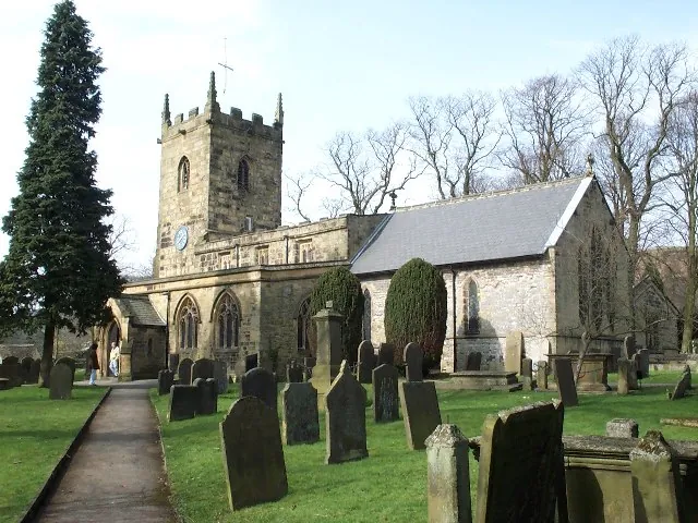
Eyam is a village and civil parish in the Derbyshire Dales, inside the Peak District National Park, with a population of 969 at the 2011 census. Lead was mined here from at least Roman times and the village later made boots and shoes; when those trades went in the later 20th century the local economy turned over to visitors, and Eyam is now promoted as “the plague village”.
That phrase is why most people come over from Bakewell, and it is worth knowing what it commits you to. The subject is fourteen months in 1665 and 1666, when plague arrived in a bundle of cloth sent from London to the village tailor and the villagers shut themselves in rather than carry it out. What survives is not one site but a scatter of them — a museum, a churchyard, a well on the hillside, graves in a field — joined up on foot, some of it steep.
The straight-line distance from Bakewell is 7.8 km. The village sits between two brooks, on ground the Domesday Book recorded as Aium, from the Old English ēġ, “an island”.
Eyam Museum opened in 1994 and covers the village’s local history as well as the plague. It holds 4.5 from 1,293 Google reviews, and reviewers treat it as the opening move, not the main event. A visitor in July 2026 wrote, “The museum is a great place to begin your visit to the village.” It is small, and reviewers say so.
Up the main street is Eyam Hall, Jacobean in style, built just after the plague; the National Trust managed it until December 2017, and the owners, the Wright family, run it now. The courtyard carries 4.4 from 783 Google reviews, mostly for shopping and coffee rather than history — “Pretty place with quirky shops and lovely cafe,” a visitor wrote in July 2026. Do not assume it will be open: a visitor in July 2026 recorded it as “Beautiful - not opened so will definitely return”.
The green opposite has an old set of village stocks, and the one pub, the Miner’s Arms, was built in 1630 and named for the older trade.
The Riley graves, an isolated enclosure now in National Trust guardianship, hold Elizabeth Hancock’s husband and six children, all buried by her in eight days; she was never infected. They carry 4.6 from 161 Google reviews, with two warnings attached: it is a climb, and the way in is over a stile. A visitor in July 2026 wrote, “A pleasant, if steep walk up to the graves. Very disappointed that the only access is over a stile which made it inaccessible for my husband who has a back injury.”
Mompesson’s Well, on the hill above the village, is one of the points where merchants from nearby villages left supplies and the villagers left money, disinfected in vinegar; the Boundary Stone in the fields towards Stoney Middleton did the same work, one of several plague stones marking the line neither side was to cross. The well is 4.3 from 83 Google reviews, and opinion divides on whether the walk repays. A visitor in May 2026 called it a “Lovely challenge uphill steep walk from the village to the well”; another in July 2026 wrote, “just a well down side of a path nothing special”. Both left five stars.
Services were moved out of St Lawrence’s to Cucklett Delph, a natural amphitheatre, so people could stand apart; Plague Sunday has been marked since the bicentenary in 1866 and falls there on the last Sunday in August, alongside the older Wakes Week and well dressing. Sir William Hill Trig Point, higher again, shows 4.8 from 29 Google reviews — too small a sample to mean much.
The cloth came for Alexander Hadfield, the local tailor; his assistant George Viccars opened the damp bundle and was dead within a week. The villagers turned to their rector, William Mompesson, and to Thomas Stanley, the ejected Puritan minister; from May 1666 families buried their own dead, services moved outdoors and the village quarantined itself.
The toll is genuinely uncertain: one account gives at least 260 dead and only 83 survivors out of 350, another 430 survivors from around 800, and the church’s own record names 273 victims. Catherine Mompesson, who stayed with her husband rather than leave with her family and died in the final days, has a tabletop grave in the churchyard, wreathed each Plague Sunday.
The story has had sceptics for well over a century. Charles Creighton, in 1891, accepted the account but judged the decisions of 1666 well-meaning and mistaken: the villagers “were sacrificed… to an idea, and to an idea which we may now say was not scientifically sound”. A 2005 study called the tale a literary construct assembled afterwards by poets and local historians. Against that, a 2016 study by Didelot and Whittles found the isolation did help stop the spread.
Within a three-mile radius there are 439 known mines, some running beneath the village, drained by 49 soughs. Mining continued into the 19th century, then changed over to fluorspar as a slagging agent in smelting; the last mine to close, Ladywash, worked from 1948 to 1979. By the 1881 census most men mined lead or made boots and shoes, a trade that ended only in the 1960s.
Two things in the churchyard repay a look: the 8th-century Anglo-Saxon cross, Grade I listed and a scheduled monument, almost complete but for a missing section of shaft; and the headstone of Harry Bagshaw, a Derbyshire cricketer and later umpire, carved with a hand pointing upwards and, below it, a bat and stumps with the bails flying off.
The material behind this guide establishes no bus or train service between Bakewell and Eyam, so do not build a day around one without checking locally first. Neither place has a station: the railway through Bakewell closed in 1968, and the nearest served station is Grindleford, 10.7 km from Bakewell on the hourly Northern-operated Hope Valley line between Sheffield and Manchester Piccadilly.
The assumption is a car, a bike or your own legs. However you arrive, the walking starts on the spot: the museum and the hall are on the street, the graves, the well and the trig point above it.
The village and what is around it, at walking scale.
Open any of them in Google Maps for directions and current opening.
Attractions, prices and availability in Bakewell
These come from GetYourGuide's booking widget, which sets their cookies in your browser. Consent to load it and see the attractions and prices.
Background on Eyam draws on its Wikipedia article, text there being available under CC BY-SA 4.0.