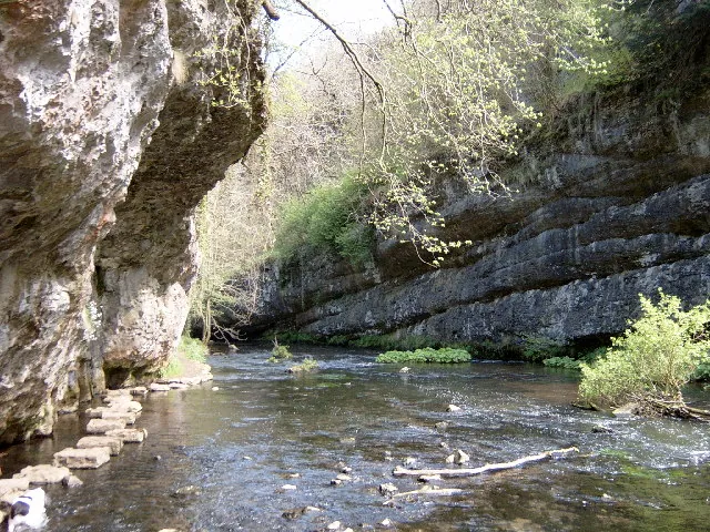
Chee Dale is a gorge on the River Wye between Bakewell and Buxton, ten kilometres west of the town, and it contains the single most memorable stretch of path in the Peak District. In two places the limestone walls come down so hard against the water that there is no bank at all — and rather than tunnel or bridge, the path simply takes to the river on stepping stones set along the base of the cliff.
You walk along the water with a hundred feet of rock overhead and the river running past your boots. There is nothing else like it in England.
The Wye cuts through carboniferous limestone here, leaving vertical cliffs, overhangs and buttresses. It is a Derbyshire Wildlife Trust nature reserve near Wormhill, part of the wider Wye Valley SSSI, and the vegetation is exceptional — ash woodland on the slopes, ferns and mosses on the wet rock, and a limestone flora on the ledges.
The cliffs are also among the most important sport climbing venues in Britain, and you will often see climbers on them.
Two sets, a few hundred metres apart, on the stretch between Wormhill and the Monsal Trail.
They are flat-topped limestone blocks set into the riverbed at the foot of the cliff, and crossing them is straightforward in normal conditions — flat feet, one at a time, hands on the rock.
They flood. After sustained rain the Wye rises and the stones go under, sometimes by a good depth, and the route becomes impassable. There is no alternative path at that point: you turn round. People get caught out every winter, and every year somebody attempts it anyway and regrets it.
Check the river level or recent reports before setting out, and if the stones are under water, take the Monsal Trail above instead, which stays open.
The usual route starts from the Monsal Trail at Miller’s Dale — where there is a car park at the old station — and drops off the trackbed into the gorge, following the river upstream through the stepping-stone sections and back up to the trail, making a circuit of about six kilometres.
Time: two to three hours for the circuit.
Surface: rocky, rooty, wet, and uneven throughout, with the stepping stones themselves. This is not a stroll and it is not suitable for anyone unsteady on their feet, for pushchairs, or for dogs that cannot handle rock steps.
Footwear: boots. The limestone is slippery when wet, which it usually is in the gorge.
The Monsal Trail runs along the top of the same valley on the old railway trackbed — level, surfaced, through lit tunnels — and gives a completely different and much easier view of the same landscape. Doing the trail one way and the gorge the other is the best day here.
Our Monsal Trail guide covers the upper route.
Parking: Miller’s Dale station car park on the Monsal Trail, charged. Mobile signal in the gorge is poor to non-existent, which affects app-based parking payment — take that into account.
Facilities: toilets at Miller’s Dale; nothing in the gorge.
Season: summer for the safest crossing; spring for the woodland flowers; autumn for the colour. Winter is when the stones are most likely to be under water.
Wildlife: dippers and grey wagtails on the river, peregrines on the crags, and a rich limestone flora.
By car: Miller’s Dale, off the B6049 north of Taddington, ten kilometres west of Bakewell.
On foot or by bike: along the Monsal Trail from Bakewell, about thirteen kilometres, which is a long but level approach.
Not in normal conditions, if you take them slowly and wear boots. After rain they flood and become impassable — that is when people get into difficulty.
Check recent walkers’ reports or the river level before setting out. If it has rained hard for a day, assume they are.
About six kilometres and two to three hours for the circuit from Miller’s Dale, on rough ground.
For confident older children, yes, with close supervision. Not for young children, and not for pushchairs.
The Monsal Trail above the gorge — level, surfaced and open in any conditions.